


rando-le teil 2014

royco
User
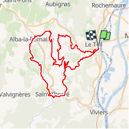

Length
46 km

Max alt
439 m

Uphill gradient
1216 m
Km-Effort
62 km

Min alt
69 m

Downhill gradient
1217 m
Boucle
Yes
Creation date :
2014-12-10 00:00:00.0
Updated on :
2014-12-10 00:00:00.0
3h57
Difficulty : Difficult

FREE GPS app for hiking
 SityTrail
IGN / Geographical institutes
SityTrail Plus
The world is yours!
About
Trail Mountain bike of 46 km to be discovered at Auvergne-Rhône-Alpes, Ardèche, Le Teil. This trail is proposed by royco.
Positioning
Country:
France
Region :
Auvergne-Rhône-Alpes
Department/Province :
Ardèche
Municipality :
Le Teil
Location:
Unknown
Start:(Dec)
Start:(UTM)
634138 ; 4934037 (31T) N.
Comments
Pratique et bien mais le téléchargement des cartes ne permet pas toujours un fonctionnement hors ligne satisfaisant.